Showing posts with label google maps navigation. Show all posts

Monday, March 7, 2011

You’ve got better things to do than wait in traffic

Ever been stuck in traffic, only to find out you’d have been better off going a bit out of your way to take a less congested route? If you’re like me, you probably hear the traffic report telling you what you already know: traffic is bad on the road you’re currently on, and you should have taken another. It doesn’t need to be this way, and we want to help. So we’re happy to announce that Google Maps Navigation (Beta) will now automatically route you around traffic. With more than 35 million miles driven by Navigation users every day, this should add up to quite a bit of time saved!

On a recent trip to New York, I was running late to meet some friends at the Queens Museum of Art. I had no idea that there was a traffic jam along the route I would normally have taken. Thankfully, Navigation routed me around traffic. I didn’t even have to know that there was a traffic jam on I-495, and I got to enjoy a much faster trip on I-278 instead.

Navigation now uses real-time traffic conditions to automatically route you around traffic.

You don’t have to do anything to be routed around traffic; just start Navigation like you normally would, either from the Navigation app or from within Google Maps. Before today, Navigation would choose whichever route was fastest, without taking current traffic conditions into account. It would also generate additional alternate directions, such as the shortest route or one that uses highways instead of side roads. Starting today, our routing algorithms will also apply our knowledge of current and historical traffic to select the fastest route from those alternates. That means that Navigation will automatically guide you along the best route given the current traffic conditions.

Not only can you save time and fuel, you’re making traffic better for everyone else by avoiding traffic jams. Keep in mind that we can’t guarantee that Navigation will be able to find a faster way, but it will always try to get you where you’re going as fast as possible.

You can begin routing around traffic with Google Maps Navigation for Android in North America and Europe where both Navigation and real-time traffic data are available.

Enjoy your newly found free time!

Friday, December 17, 2010

Under the hood of Google Maps 5.0 for Android

(Cross-posted from the Official Google Blog)

Yesterday we introduced Google Maps 5.0 for Android with two significant new features: 3D interaction and offline reliability. In order to create these features, we rebuilt Maps using vector graphics to dynamically draw the map as you use it. Building a vector graphics engine capable of achieving the visual quality and performance level you expect from Google Maps was a major technical challenge and enables all sorts of future possibilities. So we wanted to give you a closer look under the hood at the technology driving the next generation of mobile maps.

Vector graphics
Before diving into how Maps uses vector graphics, it may be helpful to understand how maps were created before. Previously, Google Maps downloaded the map as sets of individual 256x256 pixel “image tiles.” Each pre-rendered image tile was downloaded with its own section of map imagery, roads, labels and other features baked right in. Google Maps would download each tile as you needed it and then stitch sets together to form the map you see. It takes more than 360 billion tiles to cover the whole world at 20 zoom levels!

Now, we use vector graphics to dynamically draw the map. Maps will download “vector tiles” that describe the underlying geometry of the map. You can think of them as the blueprints needed to draw a map, instead of static map images. Because you only need to download the blueprints, the amount of data needed to draw maps from vector tiles is drastically less than when downloading pre-rendered image tiles. Google Maps isn’t the first mobile app to use vector graphics—in fact, Google Earth and our Navigation (Beta) feature do already. But a combination of modern device hardware and innovative engineering allow us to stream vector tiles efficiently and render them smoothly, while maintaining the speed and readability we require in Google Maps. Just try it out and see for yourself!

See the difference between image tiles (left) and vector tiles (right) tilted to show 3D buildings.

One map, many perspectives
Using vector tiles instead of image tiles gives Maps the flexibility to re-draw the same map from different perspectives using the same set of data. Zooming is one example of this at work. If you magnify an map image tile by 2x, lines such as roads and text would get twice as wide and appear blurry. As a result, we had to constrain Maps to 20 fixed “zoom levels,” each one twice as close as the last. Every time you zoomed in further, you’d need to download a completely new set of image tiles. It took time to load new data over a mobile data connection, and would fail when you lost your connection in a subway or large building.

Compared to image tiles (left), vector tiles (right) keep lines and labels crisp as you zoom.

With vector graphics, you no longer need to “round” to the nearest zoom level and then download all the tiles for that level. One vector tile has the underlying vector data (or blueprints) to draw the map at many different levels of scale. So when you zoom, the map stops when your fingers stop, and roads and labels always stay crisp. This same technique powers the new 3D map interactions: tilt, rotate and compass mode. Just like with zooming, Maps uses the same vector data to draw the map from any angle or direction as you tilt or rotate.

We can also display entirely new levels of detail that weren’t possible with flat image tiles. For example, in the 100+ cities where we have 3D building data, each building is drawn in 3D using a polygonal building footprint and heights for different parts of the building. And with tilt and rotate, you can see them from a variety of different angles.

Reading the map
Just like other map features, labels are dynamically drawn so they continue to face you and stay legible if you rotate the rest of the map or use compass mode. Maps also “chooses” the best labels to show you based on several factors. You’ll notice labels fade in and out as you interact with the map so that the most useful ones appear and the map never gets too cluttered.

See the difference between rotating maps with static labels (left) and dynamic labels (right).

Vector graphics also allow us to draw additional data on the map more clearly. For example, traffic or transit lines no longer block the labels beneath them. We can also draw the same map in different styles — like “satellite view” where the roads are translucent over aerial imagery, or Navigation’s “night mode” where a darker palette helps your eyes adjust quickly in the lower light.

Previously, map features like labels and traffic could conflict (left) instead of blend seamlessly (right).

Offline reliability
Vector graphics also enable another significant new feature: the ability to continue viewing maps even when you have poor—or no—network connections. Because each vector tile works across multiple zoom levels, it requires more than 100 times less data to view maps across all zoom levels than before, allowing Maps to cache much larger areas of the map on your device.

With this first version, Maps proactively caches map data for the places you use Maps the most—where you’re actively using it as well as places for which you search or get directions. Then when you’re plugged in and connected over WiFi, caching happens automatically. Near your frequent places, you’ll get detailed vector tiles for city-sized regions so you can see every road labeled. Further away, you’ll have less detail but will typically have towns and highways labeled for miles. We’re continuing to work on these algorithms, so you’ll see improvements over time.

Offline rerouting
With Google Maps Navigation (Beta), you’ll also see the benefits of additional caching with offline rerouting. This feature is only possible because Navigation caches not only map data but also data like turn restrictions for the areas surrounding your route. You’ll still need to be connected when you first start a trip to download and cache your route. But this way, even if you take a wrong turn after losing your connection, Navigation can use the cached data to get you back on your way. We will be rolling this feature out gradually over the next few weeks.

This is just the start, and we’re really excited about all the possible ways to use vector graphics technology for the next generation of Google Maps. So please stay tuned!

Update (12:47pm PST): Tweaked the description of the difference between image maps zoom levels.

Thursday, December 16, 2010

The next generation of mobile maps

(Cross-posted from the Official Google Blog and the Google Lat Long Blog)

Update (12/17/2010 11:30am PST): Check out a related post on the technology powering Google Maps 5.0 for Android.

I’m excited to announce Google Maps 5.0 for Android, with two significant new features: 3D interaction and offline reliability.

We launched Google Maps for mobile a little more than five years ago. Since then, we’ve added dozens of features, and we’ve grown from a few thousand to more than 100 million users. Still, a couple of things have remained the same: a flat, north-up map and the need for a strong Internet connection. Today, we’re changing that for the first time.

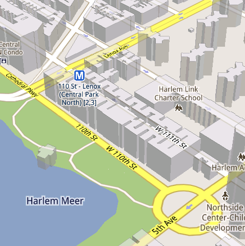
Tilt while zoomed in (left) or use compass mode (right) to orient yourself with 3D buildings.

Explore maps in 3D
Until now, Google Maps has always downloaded the map as a set of small, square images that we stitch together to form the map you see. (You’ve probably seen those gray squares getting filled in, block-by-block, as the images load over the network.) Starting today, we’ll use vector graphics to dynamically draw the map on your device as you use it, allowing you to interact with it in new ways:
  • Tilting: Drag down with two fingers to tilt the map. Tilt while zoomed in on one of the 100+ cities around the world with 3D buildings to see a skyline spring to life.
  • Rotating: Twist with two fingers to rotate the map. After tilting to see 3D buildings, rotate around them to gain a new perspective from any direction.
  • Smooth zooming: Slide two fingers together or apart, and see the map and labels continuously scale to any zoom level, stopping when your fingers stop.
  • Compass mode: Center the map on your location, and then tap the compass button in the top right corner. The map will flip into 3D mode and start rotating to match your perspective, while still keeping all the labels upright and readable.
I found 3D buildings especially useful on a recent trip to New York. From my hotel to the Google office in Chelsea and bars on the Lower East Side, this richer representation of the real world made the map much more helpful. And whenever I walked out of a building or subway station, I used compass mode to get myself quickly oriented and on my way. Check out the video below to see tilt, rotation, zoom and compass mode in action, or see more pictures.


Offline reliability
Google Maps has always been, and continues to be, a fundamentally Internet-connected experience, meaning you always get the freshest map and place data, search and voice search, live traffic conditions, satellite and Street View imagery, and much more. Still, we understand that mobile Internet connections aren’t 100% reliable. So today we’re happy to take the first steps toward greater offline reliability, so you can find your way even if you lose your connection.

In the past, you’ve probably had frustrating moments when you get stranded without a map, whether ducking into the subway, sitting at the back of a restaurant or traveling anywhere with a flaky Internet connection. But dynamically drawing maps requires 100 times less data to get maps across all zoom levels, so now we’re able to proactively cache (or store) large areas on your device based on where you use Maps the most. This way, you can rely on having fast, robust maps available to you where you’re most likely to need them.

For example, I live in San Francisco and work in Mountain View, so Maps makes sure I can always pull up detailed street maps of each city and area maps for the whole San Francisco Bay Area. When I do have an Internet connection, I still get live traffic, imagery, richer map details and all the other features I’m used to with Google Maps.

Rather than having a static set of maps when installed, Maps will automatically start caching the areas you visit the most when your device is plugged in and connected to WiFi (e.g., the nightly charge). We’re already hard at work improving the algorithms and technology behind these features, so over time you can expect to see maps work better in more offline situations.

Offline rerouting
If you’re one of the more than 10 million people relying on Google Maps Navigation (Beta), our free turn-by-turn GPS navigation feature, losing your Internet connection can be particularly painful. (This happened to me on a recent ski trip to Tahoe, and I was left trying to manually find my way back to my route.) So we’re also introducing offline rerouting. You’ll still need a connection to start a route, but if you miss a turn along the way, we’ll quickly get you back on track, even if you don’t have an Internet connection. We’ll be rolling this feature out gradually over the next few weeks.

Google Maps Navigation now automatically reroutes you, even if you lose your connection.

These new features are just the first steps in maximizing dynamic map drawing technology to create a faster, more interactive experience where efficiency really matters: mobile devices. For example, we estimate that viewing maps now requires almost 70% less mobile network data overall than before. We can’t wait to take the next steps in making Google Maps faster, more reliable and even more useful no matter where you take it.

Get Google Maps for mobile 5.0 by searching for Google Maps in Android Market (or tap on this link if you’re on your phone). Android 1.6+ devices can get Maps 5.0, but 3D and offline features require Android 2.0+, and some features may not be supported for all devices or countries.

So try it out. Wander around in compass mode, explore 3D buildings—even dare to open Maps on the subway! I hope you enjoy all the new features as much as we do.

Thursday, September 9, 2010

Walk this way

Whether you’re going for an urban hike or wandering from your hotel to find that restaurant you passed earlier, you won’t have to flag down a local if you’ve got Google Maps for mobile 4.5 on Android. Maps already had Navigation and walking directions, and today we’re happy to share the perfect marriage of the two: Walking Navigation (Beta). If you need help deciding where to walk (or drive), you can now also use Street View smart navigation or the new Google Maps search bar to guide your choice.

Walking Navigation
Walking Navigation lets you use GPS navigation with walking directions that are more direct and use pedestrian pathways when we know about them. To try it now, choose the “Walking” option from the Navigation icon. Walking Navigation has a few changes that help when you’re on your feet. For example, your phone will vibrate when you need to make a turn. You can even turn off voice guidance and just use these notifications while soaking in the sights and sounds around you. To help you orient yourself with your surroundings, the map will rotate with you as you turn the phone, and walking mode uses satellite view by default. Use it like a virtual compass with satellite imagery to look ahead or help pick out landmarks along the way.


Choose the “Walking” option after selecting the Navigation icon (left) to use Walking Navigation (right).


Keep in mind that Walking Navigation is still in beta, and Google Maps may not always have up-to-date information or optimal walking routes. Whether you’re walking or driving with Google Maps Navigation, you should always be safe and pay attention to road signs, follow signals, and use good judgment about routes that can’t be walked.

Street View smart navigation
If you want a sneak preview of where you’re going, use the new Street View on Google Maps with smart navigation and updated imagery. Just like with Street View smart navigation on your computer, you no longer have to slowly move down a street by tapping arrows along roads repeatedly. Now you can quickly navigate Street View by dragging Pegman from the corner and highlighting where you want to go with a lightly shaded “pancake” on roads or a rectangle on buildings. Let go of the screen when highlighting the front of a building, and you’ll fly there and turn to face it. With a swipe of your finger, you can hop rivers and scale buildings.


You’ll need to download an update for the “Street View on Google Maps” app in Android Market separately from Google Maps. Once you update, access Street View just like before: open Maps, search for a place or long-press the map, and choose the Street View option if available.

New Google Maps search bar
At the top of the map, you’ll find the new Google Maps search bar always available for easy access. Tap it to quickly start searching, open Places, use the Layers menu, or find yourself on the map with My Location. Here are more new features that may be helpful when you’re looking for nearby places:
  • Filter search results by distance or ratings
  • View prices categorized with dollar signs
  • See cross streets for places.
Google Maps for mobile 4.5 and Street View smart navigation are available now for Android 1.6+ everywhere they’re currently available. Search for Google Maps (tap here on your phone) and then Street View on Google Maps (tap here) in Android Market to update both.

Visit our Help Center to learn more or tell us your feedback and questions in our Help Forum. Give us suggestions and vote on other people’s on the Mobile Product Ideas page.

Wednesday, June 9, 2010

Fun on the Autobahn: Google Maps Navigation in 11 more Countries

There’s nothing quite like driving through Europe in the summer. In the past week, I’ve seen the beautiful Val d’Aosta, the Swiss Alps, the Cathedral in Chartres, and travelled through the Channel Tunnel as I road-tripped from Milan to Geneva, Zürich to Stuttgart, and on through Paris to London. Why the burst of mileage? Well, I’ve been testing Google Maps Navigation version 4.2. Yes, road-testing it around Europe was a grueling process, but somebody had to do it :)

Today we’re launching Google Maps Navigation version 4.2 in Austria, Belgium, Canada, Denmark, France, Germany, Italy, the Netherlands, Portugal, Spain, and Switzerland for Android devices 1.6 and higher. Google Maps Navigation is an Internet-connected GPS navigation or ‘satnav’ system that provides turn-by-turn voice guidance as a free feature of Google Maps.


On my test trip, I found a number of Navigation features useful:
  • While driving through the Loire Valley, I put my French language skills to the test by finding my destination with Search by voice (now launched in French, German, Italian, and Spanish for Android 2.0 and higher);
  • I previewed a typical British roundabout with Street View to see exactly where I’d need to exit before getting there in person;
  • I satisfied my craving for moules frites by searching for it along my route;
  • I kept the gas stations layer on to ensure I’d always know where the nearest petrol station was, just in case;
  • And, of course, the turn-by-turn voice guidance kept me on-track to my destination -- despite my sometimes spotty connection in mountain tunnels -- thanks to the way Maps Navigation saves the route on your device when you start.
Google Maps Navigation (beta) with Search by voice is available in version 4.2 of Google Maps, on Android devices 1.6 and higher. To download Google Maps version 4.2, search for Google Maps in Android Market.

Try Google Maps Navigation in your local country and language today -- and have a great time touring around the Continent this summer if you get the chance!